 |
Associated pages: |
 In 1834, the French explorer Eugène de Sartiges discovered the ruins of Choquequirao. However, when American explorer Hiram Bingham passed through this area 67 years later, in 1901, while searching for archaeological treasures, he did not see Choquequirao. Instead, he discovered what would make him famous: Machu Picchu.
Today, Choquequirao is considered a new archaeological marvel of Peru and is often compared to Machu Picchu for its historical importance and grand architecture. However, unlike its more famous counterpart, Choquequirao remains relatively unknown, making it particularly attractive to those seeking a more authentic and less touristic experience.
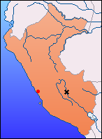
Choquequirao, which means "the cradle of gold" in Quechua, is located in the La Convención province, in the department of Cusco, at an altitude of 1,500 meters. It is believed to have been an important economic hub connecting the Amazon jungle to the major cities of the Inca Empire, such as Machu Picchu and Pisac. Besides its economic role, Choquequirao also had a ceremonial and religious function, as evidenced by the many temples and ceremonial plazas discovered so far.
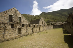
The site consists of nine sectors, including the political-religious center, a system of fountains and canals, with aqueducts showcasing the advanced hydraulic knowledge of the Incas, and the agricultural terraces covering the mountain slopes. To date, only 30% of the citadel has been excavated, leaving much to discover about its history and mysteries.
Visiting Choquequirao is no easy task. Unlike Machu Picchu, which is accessible by train and bus, reaching Choquequirao requires several days of hiking through rugged and steep terrain. However, this effort is part of the appeal for those looking for a more adventurous experience. Along the way, travelers can enjoy breathtaking views of The Andes mountain range and encounter a wide variety of local flora and fauna, such as the Michi-Michi orchid (Cypalla Herrerae) or the Wkanki (Masdevalia Veitchiana), species endemic to the region.
For the most committed adventurers, the journey offers a unique opportunity to disconnect from the modern world and immerse themselves in the heart of the ancient Inca Empire. The trail leading to Choquequirao crosses deep gorges, rushing rivers like the Apurímac, and lush cloud forests, making it an unforgettable experience.
Choquequirao is one of Peru's greatest archaeological treasures, and while access is challenging, the reward for those who venture there is incomparable. Immersing yourself in this site steeped in history, surrounded by the majesty of The Andes, is an experience that leaves a lasting mark on every traveler.