Cordillera Blanca
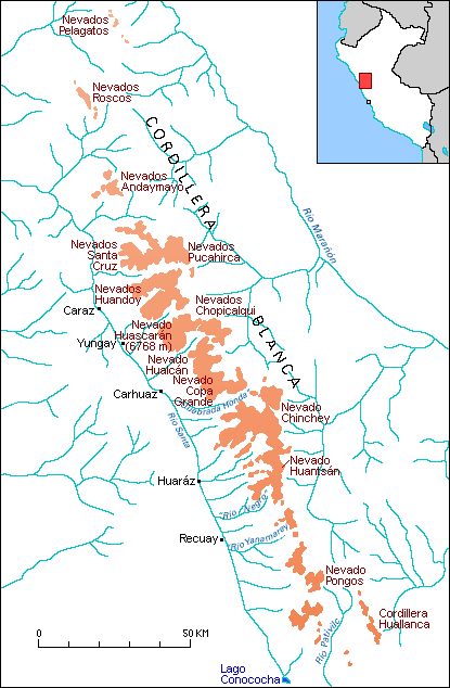
The Cordillera Blanca is the most extensive tropical ice-covered mountain range in the world and has the major ice concentration in Peru. It is part of the Cordillera Occidental and trends in a northwesterly direction for about 200 km between lat 8°08' and 9°58'S. and long 77°00' and 77°52'W. It marks the continental divide; Río Santa on the west drains into the Pacific Ocean, whereas Río Marañón on the east drains into the Atlantic Ocean. The Cordillera Blanca has five of the most spectacular peaks above 6,000 m in the Peruvian Andes. The highest peak (Nevado Huascarán) rises to an elevation of 6,768 m asl. A total of 722 individual glaciers are recognized in the Cordillera Blanca, and these cover an area of 723.4 km². Most of these glaciers are on the western side of the ranges, where 530 glaciers cover an area of 507.5 km². On the eastern side are 192 glaciers that cover an area of 215.9 km²; the lowest glacier terminus is at 4,200 m asl. Most of the glaciers, 91 percent of the total, are classified as mountain glaciers; they are generally short and have extremely steep slopes. The rest are classified as valley glaciers, except for one ice cap. Four are similar to rock glaciers.

Cordillera Blanca on Landsat Imagery
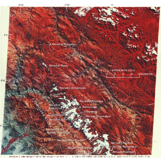
Next figure, the best available Landsat 1, 2, or 3 image of the Cordillera Blanca area, provides an excellent pictorial overview of the major glacierized areas. North of the main glacierized segment of the Cordillera Blanca can be seen the ice cover on Nevados Pelagatos and the Nevados Rosco. The great bend of the Río Santa valley (on the left center of the image) broadly marks the northern extremity of the Cordillera Blanca. The gross physiography of the area is dominated by this deep valley, as well as the Cordilleras Negra and Blanca on the west and east, respectively. It is possible to identify the separate glacierized areas on Nevados Andaymayo in the northwestern part of Cordillera Blanca.

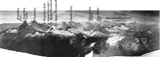
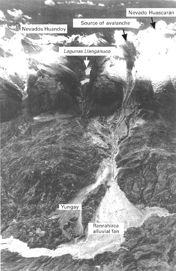
Two tributaries of Río Santa, Quebrada Quitaracsa and Quebrada Santa Cruz, bound the complex glacier system of the Nevados Pucahirca and Nevados Santa Cruz. The Quebrada Santa Cruz valley and Quebrada Llanganuco to the south delineate another glacier system, arranged in horseshoe form around Rio Parón. Within this area are the mountain peaks Aguja Nevada, Artesonraju, Chacraraju, and Nevados Huandoy. These peaks can be seen in the panoramic view shown in the next figure. The Quebrada Llanganuco and the Río Ulta bound the Huascarán massif. The saddle between the north and south peaks of Nevado Huascarán can be seen in the previous figure; particularly conspicuous are the scars of the catastrophic Huascarán debris avalanche of May 1970 that originated on the west side of the north peak and completely destroyed the city of Yungay (see next figure).


Between Río Ulta on the north and Quebrada Honda on the south, a large glacierized area culminates in the Nevado Copa Grande (6,188 m). A large, continuous glacierized area extends from the Quebrada Honda southward to about the Río Negro, but only the northern two-thirds is depicted on the Landsat image. This extensive glacierized area includes the Nevados Ocshapalca and Ranrapalca and the Laguna Llaca mountain massif. The southern part of this glacierized region and three other glacierized areas in the southern part of the Cordillera Blanca are covered by another Landsat image further south.


